Allagash Wilderness Waterway. Maine
Day 1
Bissonette Bridges to the ledges
Umsaskis Lake
Joanne, Dick, Doug, Doug’s wife, Donna, daughter Eva (9 years old), father John (86 years old) and myself arrived at the Hidden Springs Campground in Millinocket, Maine Friday evening, after a tour of every highway construction site in Vermont, New Hampshire and Maine. I’ll let Doug or Dick post the mileage to and from since I was a passenger, not a driver.
First a few words about Hidden Springs Campground, Don’t go there! This is the nosiest, rowdiest place I have ever been in. People screaming and talking loud until the wee hours of the morning without any policing from the management at all. We got very little sleep.
Saturday morning we were up early, ate, broke camp and met Jeff from Katahdin Outfitters at the entrance to the campgrounds. We loaded the trailer with out gear, parked the cars which were to be shuttled to where we would take out in Allagash, and climbed in to begin our adventure.
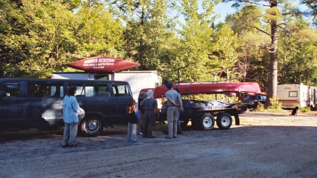
Allagash Wilderness - The Beginning

It is about 70 miles from Millinocket to where we were putting in, most on logging roads in the North Maine Woods. We had decided to avoid the Chase rapids because of our inexperience of paddling any white water and the ages of two of our party. It was a bumpy but enjoyable ride through the woods and on the trip in we saw three moose, one cow and calf, and another lone cow, on the road. We were driving through some beautiful uninhabited country.
Our driver Paul, told us that the last part of the road to the put in was going to be a “bugger”, that he hoped it was fixed, but doubted it. When we got there I looked and sure enough it was a “bugger”, real grit your teeth, four wheel drive, bump your head, road. And then he said, “They fixed it”. Sure am glad we didn’t get there before that.
As we drove down the final patch of road to the put in at Bissonette Bridge near the bottom of Chase Rapids, the ranger was coming out, having dropped off gear for a group that was shooting the rapids. According to her, the river was low and might be more difficult downstream with a lot of walking. This is the first trip I was ever on that I was hoping for at least a day of downpour.
We got to the put in and unloaded the canoes and gear and prepared to begin. We had a nice flow of water here ad just a few obstructions in the river. We had rented the canoes, Old Town Discovery 17 footers and I have to say I was impressed with these babies as we did our trip. They took a licking and just kept on going with hardly any indication of the abuse we subject them to. We gad three canoes, Dick and Joanne in one, Doug, Donna and Eva in a second, and John and I in the third.
We put in and began our journey along this marvelous, wildlife rich, wilderness river. Our goal for the first night was “The ledges” campsite on the northeast shore of Lake Umsaskis just before it runs into Lost Lake, a distance of 5.9 miles. It was immediately evident that our decision to not put in at Churchill Dam and run the rapids was a wise one. I am not that experienced in a canoe, especially with another person and so I chose the bow. John who is an experienced paddler has had recent eye surgery for cataracts and is due for a similar operation on the other eye, often sees double so we had difficulties the whole trip “being on the same page” and going in the direction that I wanted the canoe to go.
We had an “interesting” trip the first leg of the journey and in about 3 hours we reached the campsite that we had planned on. There were actually two sites there a couple that had been paddling since Chamberlain Lake used the other. The guy was from Lewiston, Maine and had done the trip before and said that the river from the five fingers deadwater to Allagash Falls and from the falls to Allagash would be pretty “scratchy” and that they were having their outfitters meet them at the Ranger Station at Michaud Farm. Based on that information and the possibility that we might have to do a lot of carrying because of low water, we all decided that we should revise our schedule to allow for the possibility that the last part of the trip might be more difficult and take longer then we had planned.
We all set up camp and ate, I think we had my sausage and peppers and onions that first night on the river, I don’t remember what meals we ate what nights. I am always going to keep a daily journal, but in recent times I have failed to do so. Just about all of the sites on the river were fantastic, beautiful areas, table, ridgepole, firepit and outhouse. My only complaint would be that they are all in big clearings with no protection from he sun.
And while I’m at it, let me mention the weather…. HOT, Hot, Hot. We were in the nineties during the days, probably the seventies in the evenings and I don’t think anyone used their sleeping bags on any night at all. For the most part, I used my Hennessey Hammock, one night I used the Bivy because I hadn’t tied the hammock right and one night I used my little one man tent because of the $%^#@*& mosquito in the hammock.

The Hawks Nest My Hennessy Hammock
Anyway, we had a nice view of the lake from the campsite. We all retired to bed right about dark since our overall plan was to be up and on the river early each day to avoid the wind. We all crawled into bed that first night, excited, well fed, and weary. Long Lake awaited us in the morning.
Day 2
Ledges, Umsaskis Lake to Cumliffe Island
9.4 miles
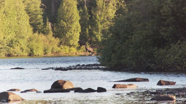
The Ledges campsite is right where Umsaskis Lake narrows to form Long Lake. After an early wakeup and a hearty breakfast, we broke camp and began our paddle to the Cumliffe Island Campsite 9.4 miles away. Another day in the nineties with bright sun all the way. The length of the narrow lake is an easy paddle, at the end of Long Lake is Long Lake Dam, a short portage according to the map. This was probably our easiest paddling day with less shallow water or rocks then any of the other sections. Here as on the first day, there are numerous herons and occasional bald eagles and even a golden eagle as well as many other species of birds. Hopefully Donna will report somewhere here on the various species of birds that were seen on the waterway, she is quite knowledgable on identifying wildlife. There are many hawks, my brother the red tail, harrier hawks, a broad shinned and a coopers hawk as well as the fish hawk or osprey as it is more commonly known. An occasional beaver, mink, otter and muskrat may be seen. There are Mergansers, Canada Goose, Mallards and Black Ducks in abundance. We finally get to Long Lake Dam and my first reaction after landing and walking to look at the dam is disappointment. It’s not much of a dam as dams go, no self respecting beaver would ever claim credit for it. I believe it was built around 1905 to drive logs down the river. We are entertained by a moose browsing on the shore downstream as we portage and break for lunch, then we continue on down river.to the campsite.

Long Lake Dam, Allagash River, Maine
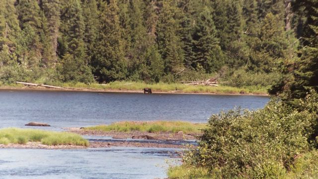
Moose!
As Eva noted earlier, this was probably the nicest of the sites, with a protected little cove between our island, another island and the river just perfect for swimming. It has been a nice day and we set up camp and have dinner (someone else is going to have to report on the menu, I can remember what we ate, but I can’t remember which days we had what. We had sausage and peppers, Bulgogi(?), Kim Che, Hamburgers, Chili, Italian Sausage, Pesto, Filet Mignon, Tortolini, and salami and cheese for lunches.).
We were entertained again by a moose browsing on the shore a little upstream from were we were camped. Once again, we all retired about dark prepared to get up early the next morning for another
early start.
Day 3 Monday
Cumliffe Island to Croque Brook
10.5 miles
Another early breakfast and we decide that because of the possibility of low water from the deadwaters between five fingers and Allagash Falls and downstream from the falls to the take out at Allagash, we will lengthen our daily paddles above what we had palanned. Subsequently we decide to push on once we get to Turk Island, our next planned destination. We break camp and get on the river at about 8 am again and begin paddling a long, narrow, winding stretch which varies between waist deep water and areas where we have to get out and line the boats through the river. It’s the third hot day in a row and this is one of the nicest stretches of river we have seen. On occasion we have some fast moving water and rocks to maneuver through and as the days goes on, we seem to get better at it. At one bend in the river we come across another cow moose in the water browsing the river bottom. Slow silent paddling gets us within 30 feet of her. I’m cursing that my digital camera is toast, and my SLR is packed away, I’m not taking a chance on that and the 300 meter zoom getting trashed. We stay and observe her for a while, Joanne is taking picture, Doug’s boat is still upstream a ways since they stopped earlier for a nature call. We continue on this stretch of river. Alternately paddling, dragging or dodging rocks. We finally get to and paddle the length of round pond, past the ranger station and pull in at Turk Island for lunch. The ranger comes over and chats with us and we affirm our decision to try to cover more ground the next couple of days. We finish lunch and then leave turk island and paddle to Croque Brook further downstram. Most of the campsites now have some nice open forest just beyond the claring and we are pitching our tents and my Hammock there. It’s cooler and shadier there. Anoither great dinner and an early to bed.
Day 4 Tuesday
Croque Brook to Taylor landing
16.3 Miles
In the morning as we are having breakfast, we observe another moose browsing downstream. Once again we pack the canoes and put into the river. Our goal for the day is Michaud Farm, campsite, and Ranger Station. Hopefully we will learn about the river levels and possibly get a weather report. If necessary, we can contact an outfitter and be taken out there if the river is too low ahead. This will be out longest paddle since starting and will put us two days ahead of schedule.
It’s another Hot day. A little cooler then the others but still hot for Northern Maine. Temp is in the upper 80’s.
It’s another beautiful stretch of river. Water levels are the same as we have been experiencing,, deep enough to paddle most places but scratching along in other places and sometimes having to walk the canoes a few hundred feet. I really don’t mind “lining” the canoes, it breaks the paddling up a little.
As we round a bend, we see a moose in the middle of the river in deeper water ahead. As we approach, a calf comes running from one side of the river and crosses to the other, mama just keeps feeding in the middle of the river, submerging and then coming up again. We watch her for a while and then I want to go around but I am wary about crossing between her and the shore her calf has gone to. Dick and Joanne are to the other side of the river. John and I backpaddle a little and then make a run around her. We no sooner get past then the calf runs back into the river and joins Cowwinkle. Suddenly there is a stirring on the opposite side of the river and out run two yearlings (guessing it’s her twins from the previous year) to join mama and baby in the river. Now there are FOUR moose in the river, between Dick and Joannes boat and ours. Doug’s boat is till upstream. I guess it’s a frantic few moments for Dick and Joanne because the moose are submerging and then coming up with no idea which direction they are going to come up. But that’s their story and I’m sure that we’ll hear their version. Finally they get past the moose and we continue downstream.
The other event that occurred will tickle those who have camped with me when Wildernessphoto has been along. We pull over after a tricky set of rapids to wait for Doug’s boat and what should I find in the cobble where I wait but a full, punctured, rotten can of Spam. It seems I can’t escape the stuff anywhere.
Finally Doug’s boat joins us and we continue on to Michaud Farm where everyone is supposed to check in with the Ranger anyway. It’s Maines answer to the Trail register. It’s a large open area and it has a nice camping spot, but it’s a long carry for the gear from the river to the campsite. We talk to the Ranger and learn that the river is pretty much the same downriver as it has been so far, shallow spots that require lining the canoes, but no places where we would have to actually carry them other then the 1/3 mile portage around Allagash falls which we are prepared for anyway. There’s a “chance” of rain in the next day or so. There is also swampy area around Michaud farm which means mosquitos so we decide to go a little further downstream to Taylor Landing, which is elevated and hopefully breezy. It’s less then ¼ mile so we reach there shortly after leaving Michaud farm and make camp for the night.
Doug has been saving the Filet Mignon for a “hard” day and we charcoal and devour that and retire for the night. Our plan now is a short paddle to Allagash Falls the next day, Portage the gear and then grab the campsite just below the falls.
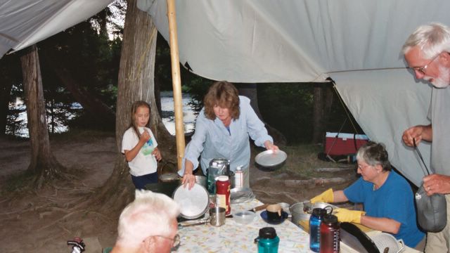
Getting ready for Dinner
Day 5
Taylor Landing to Allagash Falls
2.6 miles
We wake early (as usual), eat, break camp and paddle to Allagash Falls. There is a sign on an island in the river that is ambiguous, it says, “Danger, Falls Ahead. Keep to the right. Some of us think that it means keep to the right of the river where we are, others thinks it means to go right around the island. We take the safe course to the right of the island, have to line the canoes over some cobble and then rejoin the main channel ¼ mile ahead. Soon we see the pull out and have to maneuver around some rocks and we pul the canoes in and begin to portage the gear. Doug and I get to the end of the portage and look for the campsite just downstream below the falls, but we don’t see it. There are several nice campsites at the falls so we decide that we will stay there for the day and take our time portaging the canoes to the put in.
With the exception of portaging the gear to the campsite and the canoes to the put in, we have a leisurely day. We spend the time exploring and taking many photos of the falls, picking plump blueberries which are in abundance, swimming in the river and just relaxing in general. We decide that we will come out on Friday, a day early and will split the rest of the trip (13.8) miles in two, stopping at the last campsite before Allagash Village, Twin Brooks, eight miles ahead.
One thing I forgot to report earlier. At one point while I was in a channel, I spied the only bull moose that we saw on the river, the others were all cows or calfs. We have dinner and retire about dark again. We have been having a war with a red squirrel all day and we decide to scatter some of the nuts and trail food around the camp to keep him away from our food stores.

Allagash falls Looking downstream
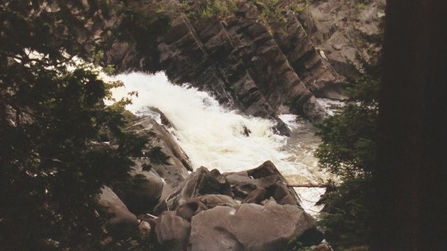
Allagash falls
Day Six
Allagash Falls to Allagash
13.8 Miles.
Daybreak, and just as we begin to stir, the squirrel has finished the tidbits we left as a diversion and is just scurrying toward the gear as Doug and I leave our tents. The plan was a success! We have breakfast and carry the gear to the boats and push off just as a party of eitght girls and their guides are portaging their gear to the put in.
We launch into the river and go a couple of hundred feet downstream and there is the campsite that we didn’t see yesterday, You have to be even with it before you can see it’s there. Anyway it’s onward to the Twin Brooks Campsite, eight miles distant.
Little do we know, this day is to be the most eventful one of the trip. By now we have all gotten a “feel” for the river. At least we’re better then when we started, and speaking for myself, pleased with how we have managed things so far. The river is still the same, flowing good in some areas and “scratchy” in others. Now when we see fast water and rocks, we paddle for the fastest moving water.
About 7 ½ miles into the day, we come to the deepest, fastest moving water yet. Doug’s canoe is in the lead and he gets hung on a rock sideways and almost dumps. I’m in a fast moving channe; and before I can react, the bow is wedged between two rocks. I can’t push off and he water is about waist deep and moving fast, but I have no choice but to get out and try to pust the boat back. Doug gets free and gets by and waits downstream. I get out and the water is up to my waist and I see John trying to get out of the canoe too. I holler ti him to stay in the canoe and now I have the bow free, but his weight shift causes the stern to come around and now the stern is facing downriver. The only chance we have is if I can walk the boat the 200 or so feet down the rapids holding on to the bow. By now, the treads on my crocs have worn pretty thin so there is not a lot of grip. The water is the deepest it has been on the river at this point (at least it seems that way) and as I walk the boat down the rapids holding on for dear life, I’m up to my shoulders and praying that I don’t run out of river bottom because there is no way I’ll be able to hold back the canoe. Finally I make it through the rapids and into shallower water and am able to get back in the canoe. Dick and Joanne make it through fine (I think, I didn’t se them come through, I was too busy). We group up and continue down the river, now looking for the campsite.
There is a road on the shore to the West and lumber trucks are raising up dust as they speed down the road. I check the GPS and we have passed the campsite, it was right at the rapids and we were so occupied we never saw it. Later on, one of the guides will tell us that he misses it all the time. We have some salami and Cheese for lunch and the decision is made that we will continue the five miles to the pull out and head for home.
The rest of the paddle is uneventful, paddle and drag the windy river until we reach the pullout where our cars await us. Shortly atfer we arrive the group of girls pull out also. We unpack the boats, pack the cars and get on the road.
Doug has suggested that it will be quicker coming back through Canada so we head towards Fort Kent to cross the border. First little store we see, Dick gets gas and I get a Moxie and everyone else gets a cold drink.
We get to Fort Kent and stop at a grocery so I can clean them out of all the Moxie on the shelf (Can’t get it around here), then we go to Subway and eat. Next it’s across the border and heading home.
It’s been a long day with the paddle and now the drive and we are all getting tired. We drive quite a distance once we are looking for a motel but don’t find anything open until we get to Plattsburg. We get rooms at the Days Inn, indulge in decadent hot showers and drop exhausted off to sleep.
In the morning we have the continental breakfast and then head for home.
A wonderful trip with the most wonderful people. I’m ready for next year but I want to do it when there is some real white water.

Allagash River

Another Moose
Same Moose, different look
posted by hawk @ 12:07 PM
0 comments
![]()

0 Comments:
Post a Comment
<< Home